Why we called it Waveshed
Short answer: a waveshed is to a radio signal what a viewshed is to your eyes, and what a watershed is to rain. It's the patch of the world that something reaches, shaped mostly by the lie of the land. Here's the longer version, because the name wasn't an accident.
It starts with water
Watershed is the oldest of the three. English picked it up around 1803 as a straight translation of the German Wasserscheide, from Wasser (water) plus scheiden (to part or divide). The -shed on the end isn't the garden building. It's an old sense of shed meaning a parting or divide, the same word you'd once have used for the parting in your hair. A watershed is the ridge line that parts the rain: water falling on one side runs to one river, water on the other side to another. Stretch the meaning a little and it becomes the whole catchment, every slope that feeds a common outlet.
Either way, the terrain does the deciding. Stand on the divide and the shape of the land sorts the raindrops for you. Hold that thought, because it's the part that carries over.
Then someone aimed it at the horizon
In 1967, a British landscape architect named Clifford Tandy needed a word for a different terrain question: from a given spot, which parts of the landscape can you actually see? He borrowed the shape of watershed and coined viewshed. The analogy is tight: a watershed is the area water flows to from the high ground; a viewshed is the area sight flows from the high ground. Swap water for light. By the following year it was running in one of the first computer programs for visibility analysis, and "viewshed" has been standard GIS vocabulary ever since, used in archaeology, urban planning, forestry and the military, all answering "what's visible from here?"
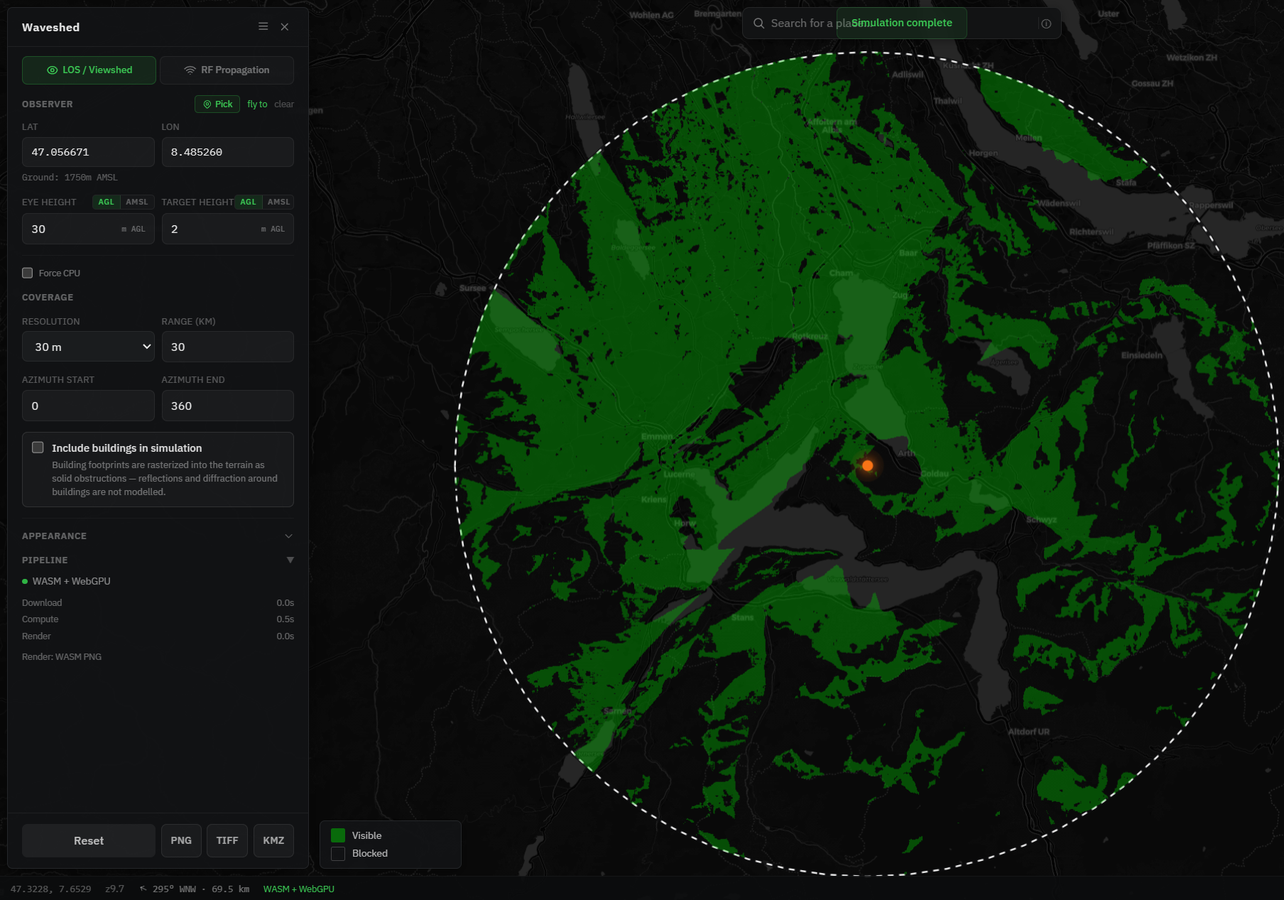
A viewshed is pure geometry: draw a straight line from your eye to every point in the landscape; the ones nothing blocks are in your viewshed. Add a small correction for the curve of the Earth and you have the optical horizon. That is exactly what Waveshed does in LOS / Viewshed mode, which is why the tool is useful to hikers and surveyors, not only to radio people. "What can I see from this summit?" is a viewshed question.
And then there's radio
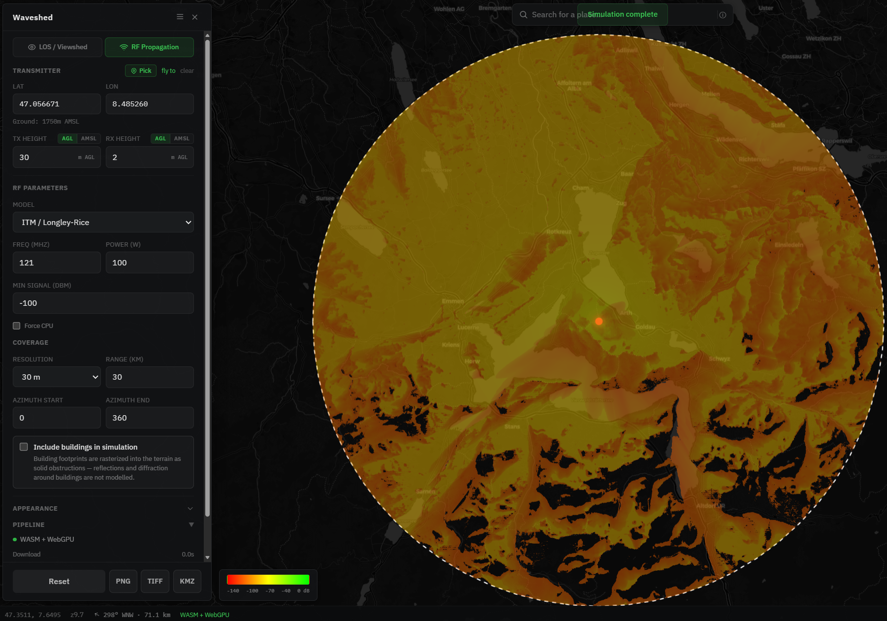
Here's the gap we wanted to fill. Light travels in near-enough straight lines, so a viewshed answers the visibility question cleanly. Radio is messier. A signal mostly behaves like sight, so hills cast shadows and valleys go dark, but it also bends slightly over the horizon, diffracts over ridges, and weakens with distance and frequency. So the area a transmitter actually reaches is shaped like a viewshed without being identical to one. (You can see the two horizons side by side in our elevation-profile tool: the optical ray for true line of sight, and the radio ray on the conventional 4/3 effective-earth radius, which reaches a touch further.) That difference deserved its own word.
There wasn't a good single one. "Coverage map," "propagation footprint," "service area": all accurate, all generic, and none of them says the thing that matters most, that the land is doing most of the shaping. The -shed family already had that idea baked in. So we took the next step in a sixty-year-old pattern:
- water → watershed where the rain goes
- sight → viewshed what you can see
- radio → waveshed where the signal reaches
A waveshed is the catchment of a transmitter: the ground its waves spill across, parted by the same ridges that part the rain. The name says, in one word, that coverage is a terrain story.
Why not just say "RF coverage"?
Two reasons, beyond the word simply being nicer to say.
First, it's honest about the method. Waveshed computes coverage from the terrain up. It pulls real elevation data and then runs either a line-of-sight viewshed or the ITM / Longley-Rice irregular-terrain model over it. It isn't a decorative heat-map laid on a map; it's a shed, derived from the shape of the ground: LOS for visibility, ITM for signal.
Second, the name spans both things the tool does. Waveshed has two modes: an optical viewshed (LOS) and an RF coverage map. "Waveshed" is the umbrella that fits both, the shed for waves, whether those waves are light or radio. One concept, one word, two modes.
What a waveshed looks like
Here is the same transmitter on Mount Rigi, the 1,798 m peak above Lake Lucerne, asked both questions at once. On the left, the LOS viewshed: green where there is a clear optical sight line to the summit, dark where terrain blocks it. On the right, the RF waveshed at 121 MHz, the same ground graded by predicted signal strength with the ITM model, fading out where the signal falls below the cutoff.
Both of those are screenshots. But when you run Waveshed yourself, every pixel is computed in your browser, on your GPU via WebGPU with a CPU fallback, straight from open elevation data, with nothing about your transmitter ever leaving the tab. That has nothing to do with the name. It comes from the same instinct: build the honest version of the thing, then call it what it is.
Map your own waveshed
Pick a hilltop, drop a point, and watch the shed fill in. It's free, runs in the browser, and needs no account.
Sources
- "Watershed," a calque of German Wasserscheide (c. 1803). Etymonline, Wiktionary.
- "Viewshed," coined by Clifford Tandy in 1967 by analogy to watershed. Wikipedia: Viewshed.