Including trees
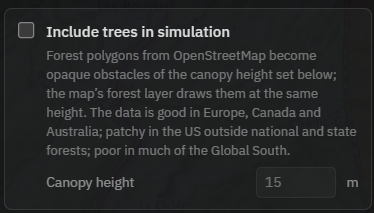
A wooded ridge can hide what bare terrain would show. Tick Include trees in simulation in the Coverage section. Mapped forest then becomes an opaque obstacle at the canopy height you choose. The box appears in line-of-sight (viewshed) mode, and RF runs ignore vegetation.
How do I switch trees on?
- Stay in “LOS / Viewshed” mode, the default. In “RF Propagation” mode the trees box is not shown, because the RF models ignore vegetation.
- Click the map to place the observer, then set “EYE HEIGHT”, about 1.7 m for a person or the mast height for an antenna.
- In the “Coverage” section, tick “Include trees in simulation”. The forest layer appears on the map, so you can see what is mapped around your point.
- Set “Canopy height”. 15 m is a sensible starting value, and the guidance below helps you refine it.
- Press “Run Simulation”. For a before-and-after comparison, untick the box and run again. The difference is the area the forest takes away.
What canopy height should I use?
One height applies to every mapped forest in the run. The default of 15 m suits mixed woodland. Young or boreal forest is closer to 12 m, and mature conifer stands reach 25 to 30 m. The field accepts 1 to 150 m.
The same number drives the display. The forest layer is draped at that height, and the 3D map styles draw every tree with it, so a tilted look at a wood you know is a quick sanity check before you run.
Can I show the forest without simulating it?
Yes. The map-style menu in the toolbar has a separate display layer, “Forest & wood (OSM)”, with the same “Canopy height” field. It drapes mapped woods over the terrain, and the 3D styles draw every tree on its own. It is display only and never changes a result.

Use it to check the data before a run, or for a 3D look at an area. The simulation checkbox is independent, and ticking that switches the display on as well, so you always see the forest a run used.
Where does the forest data come from?
The polygons are OpenStreetMap tree cover, served through the OpenFreeMap planet vector tiles. United States national and state forests count as forested even where their tree cover is not mapped in detail.
Coverage varies by region. The data is good in Europe, Canada and Australia, patchy in the US outside national and state forests, and poor in much of the Global South. Ticking the box also shows the “Forest & wood (OSM)” layer, so check what is mapped along your path before you trust a result.
What is modelled, and what is not?
Forest becomes a solid block at the set height. A sightline either clears the canopy or it does not, and no foliage attenuation is computed, so there is no partial loss in dB for grazing a treetop.
Your own spot stays clear. A small area around the observer keeps the ground height, so you can stand on a forest path without measuring from the canopy top. Target points, in contrast, stand on top of the canopy, the way they stand on roofs.
Buildings work the same way. See Including buildings for the counterpart, and the launch post Trees now block line of sight for a worked example.
Frequently asked questions
Do trees affect RF coverage?
Not yet. Trees apply to line-of-sight runs only, and the box is not shown in RF Propagation mode. RF results ignore vegetation, which is one reason the app notes that coverage may be overestimated in vegetation and urban areas.
Why is there no forest shown in my area?
Only mapped tree cover is used. OpenStreetMap forest polygons are good in Europe, Canada and Australia, patchy in the US outside national and state forests, and poor in much of the Global South. Tick the box and look at the “Forest & wood (OSM)” layer. A wood that is missing there is missing from the simulation too.
Are single trees or hedges modelled?
No. Only mapped forest polygons are raised, so an isolated tree, a row of fruit trees or a hedge does not block the view unless it is mapped as woodland. Foliage attenuation is not computed either. Forest is an opaque block at the set height.
What is the difference between the forest layer and the trees checkbox?
The “Forest & wood (OSM)” layer in the map-style menu only draws mapped woods on the map, at the set canopy height and as individual trees in the 3D styles. It never changes a result. “Include trees in simulation” feeds the same woods into the line-of-sight run as obstacles and switches the layer on as well. One canopy height drives both.